
The following article was generated with the assistance of Grok AI.
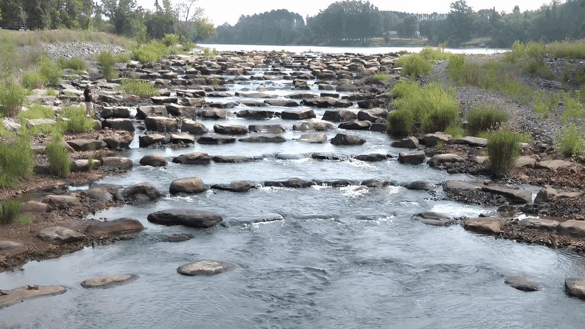
When the Minnesota DNR proposes replacing an old concrete dam with a Rock Arch Rapids (RAR) design, the primary point of contention with local communities and lake associations is almost always water levels. While the DNR values RARs for fish passage and safety, lake associations fear that removing a solid concrete weir will cause their lake levels to drop, ruining shorelines and boat docks. To get these projects approved, communities have successfully pressured the DNR and engineering partners to implement critical design modifications to the rock structures.
1. The Perkins Lake Modification (The “Narrow Notch” Design Change)
On the Pomme de Terre River watershed, the DNR partnered with the local Pomme de Terre River Association to modify the Perkins Lake outlet dam into a rock arch rapids.
The Community Challenge: Property owners noticed that the lake’s water levels had historically run about 0.6 feet higher than the state’s officially authorized level due to a past, unpermitted modification. Locals fiercely opposed the standard RAR template, fearing the lake would permanently drop over half a foot, draining shallow bays.
The Design Change: The hydraulic modeling was completely reworked. Instead of building a uniform rock slope, engineers modified the RAR design to feature a narrow, optimized notch set precisely at the authorized elevation, while keeping the rest of the surrounding rock boulder weir substantially higher. This specific architectural tweak ensured that under normal flow conditions, the lake successfully mimics the historically higher levels the homeowners fought for.
2. The Sauk River Chain of Lakes / Cold Spring Dam Study
The Sauk River Chain of Lakes Association (SRCLA) represents a massive, highly organized body of homeowners who successfully altered the DNR’s approach to replacing the aging Cold Spring Dam.
The Community Challenge: When the DNR floated the idea of a standard rock arch rapids system to bypass the high-hazard 47-year-old dam, the lake association and the city council formally intervened. Homeowners stated they did not trust the baseline DNR model to hold back enough water to support heavy recreational boat traffic across the connected lake chain. At a December 2024 Cold Spring City Council meeting, residents spoke at length about lake-level risk; the mayor voted against even a study letter.
The Design Change: Due to intense community skepticism, the DNR and Stearns SWCD had to pause any generic RAR rollout. The SRCLA and City Council both adopted resolutions supporting an exhaustive, site-specific feasibility study (channel survey, tight bend, three bridges, bedrock, and concrete embankments). Project permission was tied to proving that any rapids would be built at the existing dam height so Chain of Lakes summer levels would not drop, while still examining spring flood and freeze-over behavior. Funding for that study became a political condition of moving forward.
3. The Willow River Dam Failure and Re-Engineering (Steepness Adjustments)
Following a catastrophic 2016 flood that completely destroyed the old 1940s concrete Willow River Dam in Pine County, the DNR stepped in to restore the reservoir using rock arch rapids.
The Community Challenge: The physical drop between the upstream reservoir and the downstream riverbed was a massive 13-foot elevation change. Local paddlers, fishermen, and residents challenged the initial baseline safety assumptions, pointing out that a standard linear rock ramp over a 13-foot drop would create dangerously fast flumes and severe shear stress, entirely blocking small recreational watercraft and warm-water fish from navigating upstream. Residents also wanted a conventional dam rebuilt rather than a fish-first design.
The Design Change: The DNR and Barr Engineering had to scrap basic structural concepts and build an advanced 2D hydraulic model specifically tailored to the community’s safety and boating demands. The design was changed to feature an expanded, highly intricate sequence of descending rock arch weirs separated by wide, energy-dissipating pools. This heavy boulder layout broke up the massive water velocity, allowing the community to retain lake levels while accommodating small-boat passage when conditions permit.
4. The Green Lake / Lake Calhoun Court-Ordered Crest (Sheet-Pile Weir + RAR)
On Kandiyohi County Ditch 20 between Green Lake and Lake Calhoun, the DNR and Middle Fork Crow River Watershed District proposed replacing two aging WPA dams and a timber bridge with rock arch rapids.
The Community Challenge: This fight is older than the RAR program. After 1930s dams flooded farm fields, landowners sued Conservation Commissioner Chester Wilson. In Nelson v. Wilson (1953), the Minnesota Supreme Court held the flooding was a taking and locked in elevations and flows that still bind the site. Later high-water years brought Green Lake property owners back to the table demanding that the outlet remain a fixed structure at the court-set elevation (about 1,155.3 feet).
The Design Change: The current RAR cannot be a free-flowing fish ramp. Engineers kept the existing Lake Calhoun outlet base in place as a redundant control and added a sheet-pile weir on the diversion dam specifically to hold the 1953 court-ordered crest. Rock-arch boulders are placed up to that weir, with roughly a half-foot drop per weir and two-foot pools. Watershed officials have stated publicly: “This court case holds today. We will not change this level at all.” The DNR will own the finished rapids but cannot alter them without drainage-authority approval under Minn. Stat. ch. 103E.
5. The Pine River / Norway Lake S-Curve Riffle
The City of Pine River, MnDOT, and the DNR replaced the high-hazard Norway Lake Dam and relocated Highway 84 off the dam structure.
The Community Challenge: The city wanted the Norway Lake recreational pool, the beach, and historic WPA-era park features kept. A straight rock channel from the lake down to the Pine River would have produced too much velocity and too large a drop for fish—and would have threatened the look and use of the town park that sits on the old impoundment.
The Design Change: Digital modeling forced the team to abandon a straight ramp. The rock-riffle flow line was bent into an S-curve so the required drop could be stretched across enough horizontal distance to keep reservoir levels, pass fish, and reconnect the park. Community wishes were written into the 2017 preliminary feasibility report before Outdoor Heritage Fund support was sought.
6. Little Floyd Lake / Pelican River (Keep the Runout, Prove It in Photos)
The Pelican River Watershed District modified the Little Floyd Lake outlet dam with a rock arch rapids, completed in 2024.
The Community Challenge: Shoreland owners asked the same question that appears on every RAR project: “Will my lake level change?” They did not accept a generic assurance. Because Floyd Lake is a designated public water, any drop in the legal runout elevation would have been a statutory as well as a political problem.
The Design Change: The top step of the rapids was engineered as a replacement weir that keeps the critical dimensions and runout of the old dam. Consulting-engineer modeling was submitted with the permit application. During construction the district recorded staff-gauge readings morning and evening and published photo comparisons showing pre- and post-project elevations were the same. The community forced the project to treat water-level proof—not just fish passage—as a deliverable.
7. Little Birch Lake Outlet (Same Low-Weir Crest, Longer Weir)
The Sauk River Watershed District and the Little Birch Lake Association replaced a deteriorating 1988 concrete weir near Grey Eagle with rock arch rapids in fall 2024.
The Community Challenge: The association put $15,000 of its own money into the project and demanded that the new structure control the lake as well as, or better than, the crumbling berm. Homeowners would not accept a fishway that lowered the ordinary operating level on a lake with nearly a century of recorded elevations.
The Design Change: Houston Engineering’s design kept the low boulder-weir crest at the same elevation as the existing low weir (1,183.10 feet NAVD 1988) and only lengthened the weir from 25 to 27 feet. Rating-curve modeling was published comparing existing and proposed stages from average flow through the 100-year event, showing differences of only hundredths of a foot under ordinary conditions. The association’s participation made the “no change in crest” number part of the public design report.
8. Big Pine Lake (Leave the Concrete Weir; Stack Rock Vanes Below It)
On Big Pine Lake in Pine County, the lake association and partners proposed fish-passage vanes at the outlet rather than a full dam teardown.
The Community Challenge: Owners wanted better fish movement but refused a design that would let the lake out faster after storms or that would give the DNR a new stop-log to raise or lower the lake. They asked, in writing, whether the new structure could be used for active water-level management.
The Design Change: The accepted concept leaves the existing concrete weir in place as the elevation control and builds five rock vanes downstream of it, each about a half-foot lower than the one above. Modeling was required to show no change in surface elevations. The DNR’s answer to the stop-log request was no: raising the outlet could lift the regulatory 100-year floodplain, which the agency would not support. The community kept the old weir as the legal dam and confined the RAR to a fishway below it.
9. Crissy Lake Dam, Morris (Public Fight Over a Possible 1.6-Foot Drop)
The Pomme de Terre River Association and DNR propose replacing the 1939 Crissy Lake Dam in Morris with two rock arch rapids plus channel restoration through the shallow reservoir. An EAW comment period ran in June–July 2026.
The Community Challenge: Unlike Perkins Lake, this project openly listed options ranging from no change in water elevation to about a 1.6-foot drop in the upstream reservoir. The lake has filled with sediment since 1939 (designed 6–7 feet deep; now often 2–3 feet). Landowners and park users have to be persuaded that lowering the north end is restoration, not a taking of the swimming-beach pool the WPA built for the town.
The Design Change / Current Status: Designers have had to keep multiple elevation alternatives on the table and explain, in public fact sheets, which acres are already shallower than 1.6 feet. Proposed mitigations include a five-foot excavated channel, floodplain benches, ADA fishing platforms, and standing rocks for anglers. The project is still in environmental review. Community pressure has forced the water-level drop to be treated as a design choice that must be justified, not as an automatic byproduct of an RAR template.
10. Rochester Silver Lake Dam (“Save the Dam” vs. Engineered Rapids)
The City of Rochester proposes replacing the Silver Lake low-head dam on the South Fork Zumbro with an upstream water-control structure and engineered rock arch rapids, plus sediment removal.
The Community Challenge: The Save the Dam at Silver Lake group argues the project would erase about five acres of flat water, change a park landmark, and remove a barrier that may limit zebra mussels and invasive carp. They contend fish-passage and whitewater benefits serve a small seasonal user group at the expense of the lake’s character. City officials say the pool elevation will be maintained by the new upstream control.
The Design Change / Current Status: Community opposition split the project into two hydraulic pieces: a separate upstream control to hold Silver Lake’s level, and rapids only where the old dam stands. That is itself a concession to the water-level fight. As of mid-2026 the city reported that all major permits except the final DNR permit were in hand. No court judgment yet; the political contest is still over whether DNR will issue that last permit over organized local objection.
The Pattern
Across these sites the DNR almost never installs a textbook, uniform rock ramp and walks away. Communities win by forcing one of four design moves: (1) a narrow notch or leftover concrete/sheet-pile weir that holds a historic or court-ordered crest; (2) a longer, flatter, or S-curved ramp with extra pools so velocity does not empty the lake or block boats; (3) a published 2-D model and construction-period gauge photos proving “no change” in ordinary water level; or (4) a pause for a local feasibility study before any generic RAR is built. The legal high-water mark remains Nelson v. Wilson (1953) and the later MERA dam-crest cases: once a community locks an elevation in court or in a permit finding, the rock architecture has to be drawn around that number.