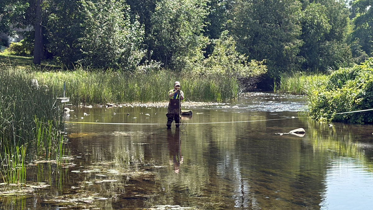
On Wednesday August 19, NE Technical Services, an independent engineering firm, conducted a discharge flow analysis on the Woman Lake Chain. Measurements were taken at three locations:
- Boy River flowing into Woman Lake at County Road 5,
- Blackwater River flowing into Woman Lake at Shore Acres; and
- Boy River flowing out of Girl Lake downstream from the rock arch rapids.
The results of these measurements are summarized in the table below:
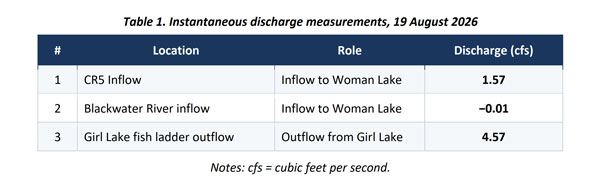
These results suggest that, at the time of the measurements, the Woman Lake chain was experiencing a net negative flow of 3.01 cfs, or approximately 22.5 gallons per second.
A detailed copy of the engineer’s report can be found here.
Please keep in mind that these measurements provide a same-day snapshot of water flow at those three locations. They are not a complete water budget for the chain of lakes. Factors such as groundwater seepage, unmeasured tributaries and wetlands, precipitation, evaporation, wind setup, and change in lake storage are not captured by three discrete channel measurements.
Recent Rainfall Not Likely A Factor
Some may wonder whether recent rainfall may have played a factor in the discharge measurements. Precipitation in the days leading up to the day of measurement was minimal. Here are the rainfall measurements from LONGVILLE 4.5 SW – Station ID: MNCS0050:
- Aug 15: 0.20 inches
- Aug 16: 0.80 inches
- Aug 17: 0.00 inches
- Aug 18: 0.01 inches
Rainfall under one inch — especially after dry weeks — is absorbed by soil, vegetation, and wetlands before it ever reaches the lake. This infiltration happens long before water can travel through the watershed and appear at the inlet culverts.
This light, scattered rainfall is not sufficient to meaningfully increase watershed inflow or produce a surge at the outlet. The measured discharge therefore reflects baseline dry‑period performance of the new RAR structure — not a rain‑driven spike.
Cumulative Net Daily Water Loss
Assuming the discharge readings remain constant to those measured on August 19, we can calculate an estimated impact on the lake chain over time. One cubic foot of water is equivalent to 7.48 gallons. Based upon the discharge measurements, the lake chain is losing:
- 22.51 gallons per second;
- 1,351 gallons per minute;
- 81,059 gallons per hour; or
- 1,945,414 gallons per day.
The daily water loss in nearly 2 million gallons. We get a sense of the scale of this number by considering the following examples:
- 2 million gallons it equivalent to approximately 3 Olympic-sized swimming pools.
- 2 million gallons would require about 300–360 tanker trucks to haul it.
- 2 million gallons would be a cube roughly 64 feet on each side — about the height of a 6-story building.
We must consider these figures are based upon measurements taken in mid-August, a time when water flows are typically much lower than during the spring of the year. If the net difference ratio between the inflows and outflow August measurements remained constant, we can only image how many gallons of water were lost during the spring of this year when water flows were much higher.
While this discharge analysis does not offer conclusive proof that the rock arch rapids is a primary cause of lower lake levels, it does provide another data point which much be included in the overall assessment of its effect.