
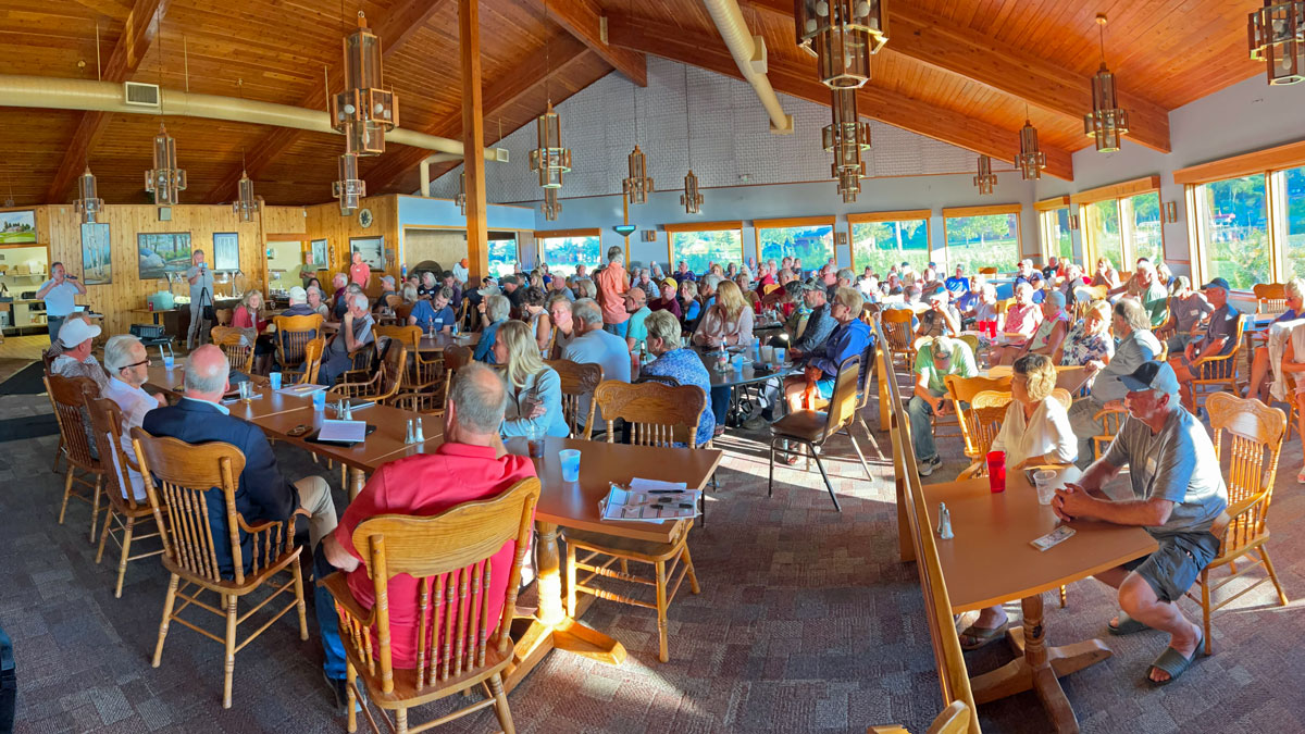
Over 200 area residents packed Patrick’s on Girl Lake on September 2, 2026, for a Woman Lake Action meeting on low water in the Child–Woman–Girl chain and the new Rock Arch Rapids at the Girl Lake outlet. Host Jeff Davis, a Woman Lake homeowner since 2003 who recently moved north full-time from the Twin Cities, opened by thanking a donor for appetizers and Patrick’s for the room, then asked people to hold questions until the end.
A copy of the slides presented at the public meeting on September 2, 2026 can be reviewed below. Meeting notes will also be posted here in the next few days (Use the arrows in the footer toobar to navigate between pages).
Same-day Letter from the DNR
Davis led with news that arrived about 1 p.m. that afternoon. Minnesota DNR Commissioner Sarah Strommen wrote Mayor Jocko Kline and the Longville clerk in response to the city’s August 19 letter on the Girl Lake outlet.
Strommen said she knows how important the Child–Woman chain is to Longville and the DNR, and that the department had reviewed engineering analysis, survey data, construction reports, and other information. The DNR remains confident the outlet was designed and built to applicable requirements and the historic authorized runout elevation, she wrote, but “questions remain about the current conditions and how the outlet is performing.”
Independent reviews are outside the DNR’s normal practice, the letter continued. “However, given the unique characteristics of this situation, we would like to work with the city to determine an appropriate scope for an independent review, identify an appropriate reviewer, and discuss sharing the cost for such a review.”
Davis called that acknowledgment “a big, big” step. How the review is scoped and paid for, he said, would be worked out in the coming weeks.
Who Is Woman Lake Action (WLA)?
WLA is a loose group of residents, not a corporation or nonprofit. It formed after lawmakers toured Longville, the dam site, and the lakes on July 31 and suggested a petition drive. The ask in the petition is an independent review of the Longville Rock Arch Rapids (RAR) project—not assignment of blame.
The group has filed Minnesota Data Practices Act requests with Cass County and the DNR, hired a hydrologist for discharge measurements, posted news and analysis at https://womanlake.org/. Members of WLA acknowledge they can make mistakes and invited corrections if their work is wrong. Cass County produced project records within weeks. The DNR had called the request too broad and costly; Davis said Strommen’s letter was the first sign the department would engage that request as well.
The petition, launched after the July 31 lawmaker visit, had more than 1,100 signatures by meeting morning, including property owners (about 67 percent of commenters) and people from 20 states. Navigation and access were the most common impacts cited, followed by wildlife, costs and property values, and tourism. Davis said WLA still does not claim the RAR is proven to be the cause. That, he said, is why they want a study.
Drought, yes — but not only drought
“We’re not drought deniers,” Davis said. The question is what role, if any, the RAR plays on top of dry weather.
WLA compiled about 135 years of local precipitation and ran a five-year average, treating a “historic drought” as a multi-year event. On that measure, they said similar or drier precipitation periods show up a large share of the record—Davis described it as on the order of 40 percent of the time—so 2026 is severe but not unique in the rainfall history they reviewed. They want a fact-based hydraulic study to separate weather from how the structure itself performs.
What a rock arch rapids is supposed to do
Using DNR language, Davis described an RAR as a nature-like replacement or modification of a failing dam: reconnect fragmented habitat so fish can move upstream, create resting and spawning pools, and provide a more stable structure. He said the old Girl Lake dam needed replacement.
Two vertical datums complicate the numbers. DNR LakeFinder levels use NGVD 29. Project engineering used NAVD 88. In Longville the conversion they cited is about 7.7 tenths of a foot. A late-August reading they showed put the lake about 5.2 inches above crest at that date.
He walked through dam terms—crest, runout, spillway, pond, foundation—and stressed that crest elevation alone is not hydraulic performance. Cass County records, he said, repeatedly state two objectives: keep the historic runout (cited as 1322.6) and provide equivalent hydraulic performance to the old outlet. Those two assurances, he said, are what an independent study should test.
Photos, excavation, and flow that “seems upside down”
The Boy River system was sketched from Ten Mile through Pleasant, Big Deep, and Pike into Child, Woman, and Girl, then downstream through Inguadona, Boy Lake, and on toward Leech Lake. The RAR sits in Longville at the Girl Lake outlet.
Photos compared the old dam (including September 3, 2005, with water over the old crest) with October 21 just before construction (little visible flow), then November and January after the RAR went in (water moving freely even with little rain or snow). Overlay images of colored rocks were used to argue the new crest sat farther upstream and that compacted foundation soils were excavated and replaced with rock, sand, and fill—raising the possibility of flow under the structure as well as over it.
On August 28, Davis photographed the Boy River under Highway 371 near Hackensack as nearly dry, then the same day photographed water still pouring at the Longville outlet. An October 13, 2022, photo of the Boy River looked stagnant after 22.3 inches of year-to-date precipitation; a September 1, 2026, photo at a similar spot showed free flow after about 15.5 inches year to date. Child Lake levels in the comparison were described as about two feet lower than a mid-August reading in the earlier period. “How do we get more rain and less flow then, and less rain and more flow now?” he asked.
Citizen complaints started in November–December after construction, he said. DNR held a Longville presentation in June. After that, residents filed data-practice requests. The city used statutory authority on August 19. A local contractor who works RAR jobs—Davis did not name him—surveyed the site the weekend before the meeting: crest rock “spot on” at 1322.6, but roughly nine-inch gaps below the crest rocks, porous backfill where old compacted soil had been, and no stainless cutoff wall of the kind the contractor said he had seen on other Minnesota RARs. County records also noted the high-water mark about 10 feet upstream of the crest and a sanitary sewer pipe found during excavation that forced a move of the weir from the original design.
Lake-level plots from May onward showed Child, Woman, and Girl dropping while Inguadona stayed higher. A mid-August photo of the Boy Lake public access showed water high on the dock. Davis said beaver stories do not close the hydraulic question.
Discharge numbers
On August 19 a local hydrologist measured flow at the County Road 5 culvert into Oak Lake (Boy River plus a tributary), at Blackwater River, and below the dam. Davis said outflow was about three times inflow, on the order of 2 million gallons a day leaving the chain in that snapshot. Critics cite evaporation; he agreed evaporation is larger, but said that does not erase the measured imbalance between inflow and outlet that day.
Money, RFP, and lawmakers
A draft request for proposals for an independent engineering study was already in volunteer hands and had been reviewed with firms. Davis said the group was about $17,000 in out-of-pocket costs and had collected about $3,000.
Checks can go to: Jeff Davis, PO box 226, Longville, MN 56655. Davis pledged transparency and plans to post donations and invoices. WLA is currently looking for a sponsoring organization to issue the RFP for an independent engineering review of the RAR. Volunteers were asked for engineering, advocacy, and bookkeeping help; letters to the Pinecone Press-Citizen, Brainerd Dispatch, and Star Tribune; and calls to Twin Cities stations (a PBS piece with Davis and Todd Johnson was already out).
Legislators and an attorney who addressed the room urged support for WLA, the City of Longville, and the legislative delegation. One speaker said the commissioner has interim authority to act before a final study if early information supports the observations, that administrative remedies should come first, and that suing the state is expensive and slow.
Davis then answered questions submitted on RSVP forms before opening the floor.
Questions submitted before the meeting
Can outflow be reduced while this is studied?
An attorney (Davis referred to James Peters) had said the commissioner has that power and could restrict flow at the rocks while the review proceeds. Whether she will, Davis said, may depend on hearing from residents. Court action without engineering data would be weak.
Is the new structure hydraulically equivalent to the old dam and channel?
That is the study question.
What is the role of drought?
Acknowledged and real, but on their five-year precipitation reading not unprecedented; it does not answer structure performance.
What happens after the study?
File the report with the commissioner and hope the data compel action. Davis pushed back on calls for an immediate class action: litigation puts the agency on defense, costs money, and takes years. Advocacy first.
Questions from the floor
What’s happening upstream at Ten Mile?
Davis said Ten Mile is spring-fed in a way he has not documented on the Woman chain, which he described as runoff-dominated. Ten Mile and lakes such as Wabedo are down with the drought, he said, but not to the same extent; the issue is whether the chain has an extra factor at the Longville outlet.
Is there documentation the old dam needed repair?
Not in the files they have received from Cass County. The DNR had not produced records yet. He hoped the review and the new letter would surface that. An audience member added that DNR talks about fish passage while taking walleye eggs each spring, and questioned whether fish will even run the river next spring if levels stay this low.
Where is the Woman Lake Association?
A resident said dozens of people were limited to about 10 minutes at an association meeting and that non-members were kept out, and asked why the association was not in the room. Davis said WLA does not speak for the association, has been a member since 2003, wants the association involved, and believes it will be needed for invasive species. Davis recommended taking association questions to the association.
Was there a pre-construction volumetric flow or rating-curve study?
A speaker said crest match is not enough; without a before-and-after flow study—ideally October 2025 versus immediately after November completion—post-project hydraulics are apples to oranges, and missing that work would be “clear negligence.”
Davis said they do not know what DNR holds. Cass County’s answer to similar questions was “no data.” Team member Ken Sauerbeck pointed to the DNR’s 2002 Birch Lake dam-replacement report (about 44 pages): two years of work with lake associations, a full rating curve from zero flow through ordinary high water and flood stage. At DNR’s June 25 Longville talk, a graph showed old-dam and RAR lines nearly on top of each other. A spreadsheet behind a similar graph, Sauerbeck said, had only seven points, all at high water, and an ordinary-high line about 13 inches above the lake’s actual OHWL. Adjusting that line broke the “identical” look. He had just asked DNR for the zero-to-OHWL flow points; staff said they did not have them on hand but would look. Davis added that Girl Lake crest citations appear to rest on records back to the 1990s and 1970s, not a Birch-style field study they can see.
How much lower will the lakes go? Who voted for this?
Residents said water has run all summer despite little rain, that DNR had described a level where flow would stop and it has not, that property owners never voted, and that Child Lake in some bays is unusable—no boat, no dock long enough across bog. Others mentioned joining forces with communities such as Pokegama that had similar fights after RAR projects, and said only a few people were told before construction.
Davis said WLA was not there to assign blame. He is not an engineer—“a simple farm boy from North Dakota”—but if more water leaves a tank than enters it, there is a problem. The weekend survey showed about five inches over the crest plus about nine inches of gaps below it, so he expects outflow to continue. On process, he agreed many in the room never got notice. Other RAR conflicts they researched often involved cities and lake associations before construction. That outreach, he said, was missing here.
Should residents flood the commissioner with letters asking her to stop outflow now?
Davis and a legislator said personal letters with photos and specifics help; canned letters get canned replies. Meet people if you can; copy legislators. WLA will post addresses, how to address the commissioner, and letter ideas—not a single form letter. Write the governor too; the commissioner is a gubernatorial appointee. Call the county assessor if access and value have collapsed. One resident asked for a simple how-to for people who do not know where to start.
What legal hook is there on the data-practice delay?
Davis said the petition, signs, and city letter are why Strommen answered Longville at all. An attorney explained Minnesota’s Data Practices Act has no 30- or 90-day deadline, so delay is fought through the administrative process or the city. The city has standing the informal group does not.
Should WLA become a nonprofit?
Possible later, Davis said, but not now. WLA is hoping to find an existing organization to sponsor the RFP process.
Near the close, residents described empty docks, missing herons and frogs, struggling loons, and Child Lake feeling like “Child Pond.” Davis thanked the room, Patrick’s, and asked people to stay for dinner.